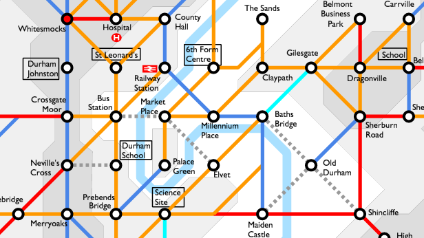
This picture is from a new diagram of cycling routes in and around Durham city. It is not meant to be a map to help you find your way. Instead it highlights the gaps in the network, by colour-coding all the links according to their safety. Blue links are the safest, red the most dangerous, and some useful missing links are shown as grey dashed lines. The most dangerous junctions are colour-coded too, with a red circle inside the black.
Despite lots of promotion of cycling over the last decade, cycling still makes up a small proportion of all journeys in Durham, far less than you would expect for a small university city. This map shows the reasons why: there are very few journeys possible that can be done entirely using the safest links. But the diagram also shows the huge potential. Some of the missing links could be sorted out relatively cheaply, and would start to give Durham a real cycle network, one which people can use for everyday journeys.
So let’s ask our County Council election candidates to back Space for Cycling and get behind the three-point pledge to
- Plan – Plan a full network of cycle-friendly routes that allow people of all ages and abilities to cycle anywhere for any purpose
- Invest – Actively seek the funding to implement the network and invest a minimum of 5-10% of the local transport budget in cycling
- Build – Build the network using the most up-to-date high quality design standards
Twenty current councillors have pledged their support already. See the Great Britain Space for Cycling map, and click on Durham to see who has signed up. We need to approach the other candidates standing in the current election to ask them to pledge their support too.
Please take a look at the full Durham City cycle network quality map and give us your comments below. Then share it with your friends and your local election candidates! We want the newly-elected Council to promise to work to fill in the gaps, by making the links blue, and creating complete routes to key destinations.
Update, 10 December 2017: Map updated to restore the link from Baths Bridge to Old Durham, following the reopening of the riverbank route past Pelaw Woods.

Brilliant. I have tried cycling to work from Chester Le Street to Net park and can now see why the last 3 miles scares me to death
Very thought provoking Stephen as 40 odd years ago that road from Sedgefield to the top of the bank near Coxhoe was a time trial course !
The turn for the 10 t t was at the gap on the dual carriageway near the pub and was a “dead turn” which shows how safe it was then.You would be a mad man to attempt that now!